General info:
Basic shot info:
Advanced shot info:
Exif-related info:
▪ Date/Time:
2004:08:10 11:40:41
▪ Exif Image Width:
700 pixels
▪ Exif Image Height:
415 pixels
HOME
»
Hawaii, February 2005
»
Viewing
Hw00b [Hawaii map]
[Image 2 of 36]
::
Jump To
- Page 1
- Page 2
- Page 3
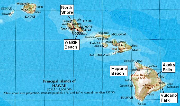
Hw00b [Hawaii map]
source: portion of
"The National Atlas of the United States of America"
, compiled by U.S. Geological Survey 2001, available from the
University of Texas at Austin
Album last updated on 7/24/05 12:29 AM
Powered by
JAlbum 5.2
and
BluPlusPlus
skin
copyright Wolfgang Schaefer, Seoul, 2005
![Hw00a [Pacific map] * 330 x 330 * (15KB)](../thumbs/Hw00a [Pacific map].jpg)
![Hw02 [Big Island Hapuna beach] * 1280 x 960 * (414KB)](../thumbs/Hw02 [Big Island Hapuna beach].jpg)
![Hw03c [Hapuna Prince Resort] * 1280 x 960 * (317KB)](../thumbs/Hw03c [Hapuna Prince Resort].jpg)
![Hw06 [Big Island Kamakua coast] * 1280 x 960 * (304KB)](../thumbs/Hw06 [Big Island Kamakua coast].jpg)
![Hw07d [Kalopa rain forest park] * 1280 x 960 * (598KB)](../thumbs/Hw07d [Kalopa rain forest park].jpg)
![Hw08a [Big Island Akaka Falls] * 1280 x 960 * (418KB)](../thumbs/Hw08a [Big Island Akaka Falls].jpg)